Thursday, April 1, 2010

Mount Ciremei


Mount Ciremei is highpoints West Java (3078 mdpl), can seen clearly by passengers trains or vehicles other generally along lane Pantura approximately Cirebon. To toward peak Ciremei there 3 pathway can pursued namely lane Majalengka lane Palutungan and lane Linggarjati. Path Linggarjati represents most precipitous and heaviest, but this pathway represents most frequently traveled climbers.

Mount Ceremai has distinctive compared mountains else in Java. This mountain situated far apart from mountain other higher and sides is the sea Java. Trip to G. Ceremai can begins from terminals Cirebon, climbed bus toward Kuningan and alight at Cilimus. From Cilimus we connect with vehicles colt or ojek to village Linggarjati.

In villages Linggarjati, we can staying at Hotel Linggarjati. From hotels Linggarjati we continue journey through buildings Scriptwriter westward until approximately Balai Desa Linggarjati. Here we meet someone former climbers or precisely caretaker, Experienced named pak Ahmad, who because age now he experiencing disturbances eyesight. Photo caretaker mountain Ciremai a respected.

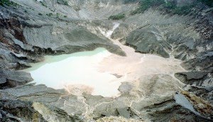
From here we walked straight and will meet pinery, ago we will until on roads branched, called Cibunar. In this place we can founded tents because availableOne wellspring. Travel continued with selecting road left toward mountaintop Ciremai. 5 hours later we shall meet an boulder, whose location pledged POS recess called Watu Lingga. From Lingga toward peak (crater) pursued within 2-3 hour journey through forests and rocklike rocks. From peak outward we could directly into crater brimstone which takes about 1 hours drive. To circled peak needed time 2 � hours, we can view interesting sights towards town Majalengka, Bandung, Sea Java and other. Down from peak to village Linggarjati taken within 3-4 hours.

Read more...

Monday, March 29, 2010

Tangkuban Perahu (boat overturned)


Tangkuban Perahu Crater is one of the attractions located in the southern region Kab. Subang, located at an altitude of 2084 m above sea level. Of natural beauty with a row of craters that stretch and cool mountain air and the expanse of the typical mountain other surrounding high-rise and the number of collections of plants and plants typical of tropical forests that flourished around the crater, making the boat Tangkuban as an attractive tourist destination in Subang regency.
Viewed from the city of Bandung, the mountain Tangkuban Parahu has a unique shape like a boat upside down (Bahasa Sunda: Tangkuban = reverse, Parahu = Boat). Unique form is believed to have a very close connection with the story Sangkuriang legends.

Enjoying the view from the crater Tangkuban Queen Boat, like seeing a giant bowl of very large and deep. When the weather clears, the curve of land on the crater wall of the crater base as well as can be seen quite clearly that it can provide a spectacular panoramic view. Glory craters so wide and deep, at least be able to force the viewer to pause and wonder for a moment the greatness of God's work.

Facilities and Tariff Entry

Gift Shop, Cafeteria and information center (TIC), souvenir shops, homestay, camping ground, outbound area, parking area, the area on horseback. The tariffs went into Tangkubanparahu attractions location of Rp 9000.

Accessibility

To go to these attractions, visitors can use either private vehicles or 2 wheels or 4 wheels of public transport. The travel time to Sari Ater attractions, namely the town of Subang with travel time approximately 40 minutes to the south of Bandung, while around 50 minutes and from Jakarta via toll SADANG with travel time approximately 3 hours while the hot water attractions with travel time Ciater 15 minutes.
Condition of the road to this area, both from Subang and Bandung is very good. However, keep in mind about the condition of the vehicle, due to the location from Bandung and Subang will go through a pretty tough climb.

Read more...

Galunggung (volcano that turned into a beautiful)


Location: Tasikmalaya Regency, West Java
Nearest City: Tasikmalaya
Country Indonesia
Type: Stratovolcano
The last eruption: 1984
Elevation: 2168 m
Coordinates: 7:25 � LS-7 � 15'0 "S; 108,058 � E-108 � 3'30" BT

Galunggung a volcano with an altitude of 2167 meters above sea level, located about 17 km from the center of Tasikmalaya. There are several tourist attractions on offer include tourism destinations and attractions wanawisata with area of approximately 120 hectares under management Perum Perhutani. Other objects covering approximately 3 hectares in the form of hot water bath (Cipanas) complete with swimming pool, shower and bathtub of hot water.
Have Galunggung Montane Forest from 1200 to 1500 meters and Forest Ericaceous> 1500 meters.

Galunggung eruption

Recorded Galunggung had erupted in 1882 (VEI = 5). Early signs known eruption in July 1822, in which water becomes turbid and Cikunir muddy. Results of the crater showed that the hot water is murky and sometimes appeared a column of smoke from the crater. Then on October 8 to 12 October, the eruption of reddish sand produces rain very hot, fine ash, hot clouds and lava. Lava flow moving toward the southeast following the river flows. This 4011 eruption killed 114 people and destroyed villages, with damage to the land to the east and south as far as 40 km from the top of the mountain.
The next eruption occurred in 1894. In between the dates 7-9 October, eruption clouds that produce heat. Then on October 30th and 27th, the lava flows occurred on the same river flows by lava eruption produced in 1822. This time the eruption destroyed 50 villages, most houses collapsed because of falling ash.

In 1918, in early July, the next eruption occurs, the earthquake begins. July 6th eruption produces ash 2-5mm thick is limited in the crater and the southern slope. And on July 9, noted the appearance of the lava dome inside the crater lake with a size of 85m-high 560x440m which was then called mountain So.

The last eruption occurred on May 5, 1982 (VEI = 4) with a thumping sound, flames, and a flash of lightning. Activities eruption lasted 9 months and ended on January 8, 1983. During the period of this eruption, about 18 people died, mostly due to the indirect cause (traffic accidents, old age, cold and food shortages). Estimated loss of about USD 1 billion and 22 villages left without occupants.

Eruption in this period has also led to changes in the radius of the map area about 20 km from the crater Galunggung, which includes Indihiang District, Sub District Sukaratu and Leuwisari. Change map of the area more dissolution caused by a network of roads and streams as well as the township area due to the abundance of cold lava flow of rock material-gravel-sand.
In the post-eruption period (ie around 1984-1990) was a period of rehabilitation of disaster areas, by restructuring the road network is lost, the dredging of mud / sand on some streams and irrigation channels (especially Cikunten I), then the construction of check dams (bag cold lava) in the area Sinagar as 'fortress' safety abundance of cold lava flood into the city area Tasikmalaya. At that time also made use of sand exploitation Galunggung considered qualified for building materials and road construction. In later years until now Galunggung sand dredging business is growing, even at the beginning of its development (approximately 1984-1985) built a network of roads near the Railway Station Railway Indihiang (Kp. Cibungkul-Parakanhonje) to check the dam as a special line sinagar to transport the sand from galungung to Jakarta.

Galunggung as tourist attraction

Most Galunggung visitor attractions are local tourists, while visitors from abroad still count under 100 people on average per year. Average tourists and abroad who visit Galunggung numbered 213,382 people per year.
Seeing the potential appeal that may be extracted, and the geographical position is strategic, and has a uniqueness of its natural conditions attractions Galunggung potential to be sold to foreign tourists. But the attractions are not packed in a professional tour packages.

Source:
http://id.wikipedia.org/wiki/Gunung_Galunggung

Source Image:

http://z.about.com/d/geology/1/0/m/9/galunggung.jpg
http://www.islandvulnerability.org/galunggung1982.jpg

Read more...

Sunday, March 28, 2010

Kujang ,Cleaver is a unique weapon of the West Java area


Cleaver is a unique weapon of the West Java area. Kujang start was made about the seventh century to the 8th or 9th, made of iron, steel and prestige material, length approximately 20 to 25 cm and weighs approximately 300 grams.

Kujang, special weapons Sunda

Replication cleaver in Bogor city monuments

Characteristics of a cleaver has tajaman side and a part, among others: papatuk / Congo (resembling a cleaver edge arrows), eluk / reparation (grooves on the back), cistern (pronounced curve in the abdomen) and eyes (small holes covered with metal gold and silver). In addition to the characteristics of very unique materials tend cleaver thin, the material is dry, porous and high in natural metal.

In Bogor Pantun as told by Anis Djatisunda (996-2000), cleaver has a variety of functions and forms. Based on the function, cleaver divided between the other four: Kujang Heritage (symbol of dignity and safety protection), Kujang Guns (to fight), Kujang Pangarak (as a ceremony) and Kujang Pamangkas (as a farming tool). While based on the blade shape is called Kujang Jago (rooster-like shape), Kujang Ciung (like birds Ciung), Kujang Egret (bird-like heron / bango), Kujang rhinoceros (rhinoceros-like), Kujang dragon (mythological animal resembling a dragon) and Kujang Kuhl (like frogs). Besides, there are also typology cleaver-shaped blade with a leather puppet heroine as a symbol of fertility.


Kujang a tool that reflects the critical acumen and power of life also symbolizes strength and courage to protect the rights and truth. Is characteristic, both as weapons, agricultural tools, symbol, decoration, or souvenirs.

In ancient times this tool is only used by certain groups of the kings, king anom, pangiwa groups, panengen, religious groups, the princess and certain women's groups

In general, Kujang has a heritage of understanding have a certain strength that comes from the gods (= Hyang), and as a weapon, since ancient till now Kujang occupies a very special position among the people of West Java (Sunda). As a symbol or symbols with niali philosophical values contained in it, Kujang used as a symbol of aesthetics in several organizations and government. In addition, Kujang was also used as a name of the organization, unity, and of course also be used by the local government of West Java Province.

Kujang in the past can not be separated from public life because of its function as a Sundanese agricultural equipment. This statement is contained in the codex Kanda Punishment Trance Karesian Ng (1518 AD) and the oral tradition that developed in several regions including in areas Rancah, Ciamis. Evidence that reinforces the statement that the cleaver as farm equipment we can still see to this point in the Baduy, Banten and Pancer Pangawinan in Sukabumi.


With the development of progress, technological, cultural, social and economic Sundanese people, Kujang underwent a shift in the development and form, function and meaning. From an agricultural equipment, cleaver developed into a body that has its own character and tends to be a valuable weapon symbolic and sacred. New form of the cleaver as we know it today was born of centuries estimated 9 to 12 century.

Mythology

According to the parents there that provide a very noble philosophy of Kujang as;

Ku-Jang-ji brand karuhun elderly neruskeun padamelan urang

Promise to continue the struggle elderly karuhun urang / ancestors of ways to enforce properties characteristic of humans and how the nation. What's that?
Cara-Man features a 5
Compassion (Love Love),
Manners (Ethics behave),
Railroad Usuk (Ethics Language),
Basa Budi Budi Daya,
Na Yuda Wiwaha Raga ( "Ngaji Agency").

Read more...

Sarangan lake

Sarangan lake which is also known as lake sand is a natural lake located at the foot of Mount Lawu, in District Plaosan, Magetan District, East Java. Located approximately 16 kilometers west of Magetan. This vast lake of about 30 hectares and 28 meters berkedalaman. With the air temperature between 18 and 25 degrees Celsius, Telaga Sarangan able to attract hundreds of thousands of visitors every year.

Telaga Sarangan a mainstay attractions Magetan. Around the lake there are two star hotels, 43 hotels jasmine class, and 18 cottage beside the tens wisata.Di souvenir kiosk, visitors can also enjoy the beautiful Sarangan with riding around the lake, or ride a boat cepat.Fasilitas other attractions also are available, such as home eat, play area, tourist market, parking, public telephone facilities, places of worship, and parks.

19 The existence of restaurants around the lake makes the visitors have a lot of alternative menu options. Similarly, the presence of street vendors who offer a variety of souvenirs has provided convenience to visitors to buy souvenirs. Specialty sold around the lake is a rabbit satay.

Magetan also helped by the potential of local small industries which can produce handicrafts for souvenirs, such as woven bamboo, leather crafts, and special food products such as emping melinjo and plate (from the rice crackers).

Telaga Sarangan also has a boat rental service and rickshaws water. There were 51 boats and 13 motor tricycles water can be used to explore the lake.

Telaga Sarangan has several important annual event calendar, the offerings on Friday labuh Pon Ruwah month, school holidays in mid-year, 1 Muharram Ledug Sura, and fireworks at night the turn of the year.

The local district government was making a project that connects the pass Telaga Sarangan with attractions Tawangmangu in Karanganyar District. Pelandaian widening project and the steep road that connects the two regions are expected to be completed in 2007.

Sightseeing can be reached from the City Magetan; and its location just off the Falls Grojogan Sewu, Tawangmangu (Karanganyar District, Central Java).

Regency Magetan also want to develop Poncol Reservoir (about 10 kilometers south of Lake Sarangan) as an alternative tourist attraction.

Read more...

  © Blogger templates The Professional Template by Ourblogtemplates.com 2008

Back to TOP