Location: Tasikmalaya Regency, West Java
Nearest City: Tasikmalaya
Country Indonesia
Type: Stratovolcano
The last eruption: 1984
Elevation: 2168 m
Coordinates: 7:25 � LS-7 � 15'0 "S; 108,058 � E-108 � 3'30" BT
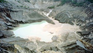
Galunggung a volcano with an altitude of 2167 meters above sea level, located about 17 km from the center of Tasikmalaya. There are several tourist attractions on offer include tourism destinations and attractions wanawisata with area of approximately 120 hectares under management Perum Perhutani. Other objects covering approximately 3 hectares in the form of hot water bath (Cipanas) complete with swimming pool, shower and bathtub of hot water.
Have Galunggung Montane Forest from 1200 to 1500 meters and Forest Ericaceous> 1500 meters.
Galunggung eruption

Recorded Galunggung had erupted in 1882 (VEI = 5). Early signs known eruption in July 1822, in which water becomes turbid and Cikunir muddy. Results of the crater showed that the hot water is murky and sometimes appeared a column of smoke from the crater. Then on October 8 to 12 October, the eruption of reddish sand produces rain very hot, fine ash, hot clouds and lava. Lava flow moving toward the southeast following the river flows. This 4011 eruption killed 114 people and destroyed villages, with damage to the land to the east and south as far as 40 km from the top of the mountain.
The next eruption occurred in 1894. In between the dates 7-9 October, eruption clouds that produce heat. Then on October 30th and 27th, the lava flows occurred on the same river flows by lava eruption produced in 1822. This time the eruption destroyed 50 villages, most houses collapsed because of falling ash.
In 1918, in early July, the next eruption occurs, the earthquake begins. July 6th eruption produces ash 2-5mm thick is limited in the crater and the southern slope. And on July 9, noted the appearance of the lava dome inside the crater lake with a size of 85m-high 560x440m which was then called mountain So.
The last eruption occurred on May 5, 1982 (VEI = 4) with a thumping sound, flames, and a flash of lightning. Activities eruption lasted 9 months and ended on January 8, 1983. During the period of this eruption, about 18 people died, mostly due to the indirect cause (traffic accidents, old age, cold and food shortages). Estimated loss of about USD 1 billion and 22 villages left without occupants.
Eruption in this period has also led to changes in the radius of the map area about 20 km from the crater Galunggung, which includes Indihiang District, Sub District Sukaratu and Leuwisari. Change map of the area more dissolution caused by a network of roads and streams as well as the township area due to the abundance of cold lava flow of rock material-gravel-sand.
In the post-eruption period (ie around 1984-1990) was a period of rehabilitation of disaster areas, by restructuring the road network is lost, the dredging of mud / sand on some streams and irrigation channels (especially Cikunten I), then the construction of check dams (bag cold lava) in the area Sinagar as 'fortress' safety abundance of cold lava flood into the city area Tasikmalaya. At that time also made use of sand exploitation Galunggung considered qualified for building materials and road construction. In later years until now Galunggung sand dredging business is growing, even at the beginning of its development (approximately 1984-1985) built a network of roads near the Railway Station Railway Indihiang (Kp. Cibungkul-Parakanhonje) to check the dam as a special line sinagar to transport the sand from galungung to Jakarta.
Galunggung as tourist attraction
Most Galunggung visitor attractions are local tourists, while visitors from abroad still count under 100 people on average per year. Average tourists and abroad who visit Galunggung numbered 213,382 people per year.
Seeing the potential appeal that may be extracted, and the geographical position is strategic, and has a uniqueness of its natural conditions attractions Galunggung potential to be sold to foreign tourists. But the attractions are not packed in a professional tour packages.
Source:
http://id.wikipedia.org/wiki/Gunung_Galunggung
Source Image:
http://z.about.com/d/geology/1/0/m/9/galunggung.jpg
http://www.islandvulnerability.org/galunggung1982.jpg
 Mount Ciremei is highpoints West Java (3078 mdpl), can seen clearly by passengers trains or vehicles other generally along lane Pantura approximately Cirebon. To toward peak Ciremei there 3 pathway can pursued namely lane Majalengka lane Palutungan and lane Linggarjati. Path Linggarjati represents most precipitous and heaviest, but this pathway represents most frequently traveled climbers.
 Mount Ceremai has distinctive compared mountains else in Java. This mountain situated far apart from mountain other higher and sides is the sea Java. Trip to G. Ceremai can begins from terminals Cirebon, climbed bus toward Kuningan and alight at Cilimus. From Cilimus we connect with vehicles colt or ojek to village Linggarjati.
 From here we walked straight and will meet pinery, ago we will until on roads branched, called Cibunar. In this place we can founded tents because availableOne wellspring. Travel continued with selecting road left toward mountaintop Ciremai. 5 hours later we shall meet an boulder, whose location pledged POS recess called Watu Lingga. From Lingga toward peak (crater) pursued within 2-3 hour journey through forests and rocklike rocks. From peak outward we could directly into crater brimstone which takes about 1 hours drive. To circled peak needed time 2 � hours, we can view interesting sights towards town Majalengka, Bandung, Sea Java and other. Down from peak to village Linggarjati taken within 3-4 hours.